GENERAL HISTORY
The Symonds Street Cemetery is Auckland’s oldest municipal cemetery. Its first burial in 1841 was a 9 year old boy named William Mason.
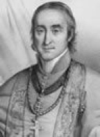
Symonds Street (and by extension the Cemetery) was named after Captain William Cornwallis Symonds, although he is not buried there. Symonds was a friend of William Hobson and one of his closest and most effective officials.
William Cornwallis Symonds was one of the first Police Magistrates in New Zealand and Chief Magistrate of Auckland. In 1841 he was appointed Deputy Surveyor-General of New Zealand.
William Cornwallis Symonds was related to the General Cornwallis who surrendered at Yorktown during the American War of Independence. William’s brother Captain John Jermyn Symonds (1819-1883) also lived in Auckland; Symonds Street in Onehunga is named after him.
William Symonds intended to create a settlement on the Manukau Harbour at Cornwallis. The Maori name for that place was Karangahape and Karangahape Road (including what is now Lower Symonds street) was part of the route taken to reach the intended settlement.
*almost all information for the history of Symonds Street Cemetery site has been collected by the K Road historian Edward Bennett.
The Auckland Council Libraries database of Symonds Street Cemetery burials is at:
HISTORICAL TIMELINE
1842
Bishop Selwyn applies to Governor Hobson for land to use as a burial ground.
20 July 1842
Hobson grants an eight acre plot to the east of Symonds Street to the Anglican Church.
4 November 1842
An additional 3 Roods and 30 perches of land are granted to the Anglican Church.
24 November 1843
One acre of land on the west side of Symonds street is granted to the Jewish Community as a burial ground.
1850
A wooden Mortuary Chapel is built in the Jewish Cemetery.
16 August 1852
Five acres are granted to Bishop Pompallier for use as a Roman Catholic Cemetery.
1865
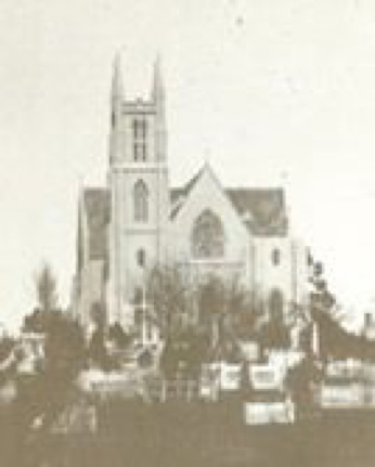
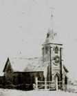
The Anglican Mortuary Chapel of the Holy Sepulchre is opened by Bishop Selwyn on Symonds Street opposite East Street.
27 August 1866
The Catholic Mortuary Chapel of St Francis de Sales is opened at the corner of Symonds and East Streets and blessed by Bishop Pompallier.
8 April 1869
Three acres are granted to the Presbyterian Church on the west side of Symonds street between the Jewish and Catholic areas.
1871
November: The “Act to Regulate Burials Near the City of Auckland 1871” is passed by Parliament to promote Public Health. However, Symonds Street Cemetery continues to be managed by the five Boards of Trustees.
11 may 1872
Three acres are granted for the use of the Wesleyan Church and others, not Anglican or Catholic or Jewish or Presbyterian. Located on the east side of Symonds Street, north of the Anglican area this is often referred to as the “General Section”
1874
Parliament passes an “Act to Provide for Closing Certain Burial Grounds 1874”. This attempts to limit further burials at Symonds street to family members of those already buried.
1876
Between 1876 and 1881 a total of 228 acres of vacant land close to the Whau River in West Auckland is reserved by the Crown as a site for a public cemetery. Eventually, 52 acres is set aside for what becomes Waikumete Cemetery.
1882
The wooden St Benedicts Church opens. This seated 1200 people and was probably the largest wooden church in the country at the time.
9 March 1885
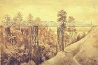
Mayor William Waddel opens the new walking bridge across Grafton or Cemetery Gully.
March 1886
The 1882 Cemeteries Act allowed local authorities to manage cemeteries and Waikumete Cemetery was opened in this month by Auckland City Council. Also, Symonds Street Cemetery was closed to new plots, but spouses, offspring and siblings could still be buried with those already buried there. The further restriction limiting burials just to those 50 years and older came in at the end of 1909.
13 December 1886
The first St Benedicts Church is destroyed by fire.
22 April 1887
The replacement brick St Benedicts Church is opened.
1895
The Chapel of St Francis de Sales is dragged down Symonds Street by bullock teams and floated over to Devonport where it is relocated on the northern slope of Takarunga/Mount Victoria in Devonport.
october 1904
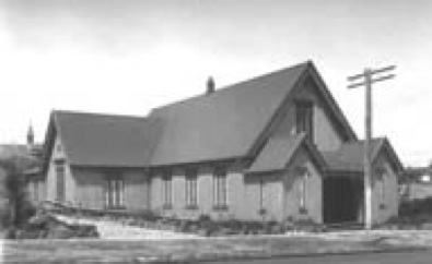
Following a report about its structural worthiness the 1885 Grafton Bridge is closed and a small temporary bridge is constructed for public use. The Chapel of the Holy Sepulchre is moved to Grange Road in Mount Eden.
1905
The Jewish Community gifts the unused portion of their sector to the City Council. Immediately proposals are put forth to use this space for a Public Building such as a Bath House. The wooden Mortuary Chapel is relocated inside the remaining Jewish Area,
16 september 1906
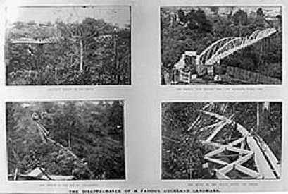
The old Grafton Bridge is demolished
1908
With the passing of the “Auckland (Symonds Street) Cemeteries Act, 1908” the cemeteries are to be formally closed to those under the age of fifty years as of 31 December 1909, along with the previous 1886 restriction on family. The cemeteries were handed over to Auckland City Council on that date as a Public Reserve.
1908
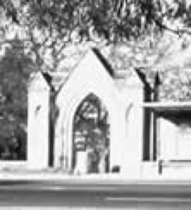
The wooden fence along the Symonds Street edge of the Anglican area is replaced by a granite wall with iron railings. A monumental Gothic Arch designed by Miss Mary Pulling is erected as the new entrance from Symonds Street.
1908
Construction starts on the third Grafton Bridge. Eight graves are disturbed and the bodies reinterred at Waikemete Cemetery.
28 april 1910
The new Grafton Bridge is formally opened.
1910
The Tram shelter and public toilets are built
1919
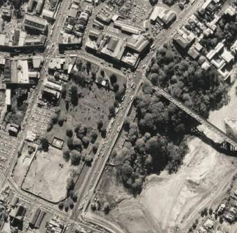
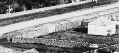
Thomas Pearson, City Parks Superintendent, reorganises the Cemetery - in particular the two sites on the corner of Symonds street and Karangahape Road and Symonds street and East Street are laid out as parks with basalt walls, rockeries, lawns and seating.
1928
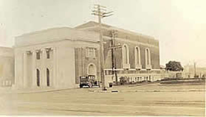
The Church of Christ Scientist Building is constructed on the corner of St Martins Lane and Symonds Street. The Neo-classical building is the only church adjacent to the cemetery which post-dates the closing of the burial ground and thus has no representatives buried therein.
1945
The great basalt rocks are removed from the Symonds Street Park. The lack of labour and budget constraints during the Second World War resulted in the rockeries becoming overgrown. These features are removed from several Auckland Parks and replaced by plain lawns and simpler shrubberies..
1952
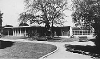
The City Council erects a Ladies Rest Room in the Symonds street Park designed by Tibor Donner (1907-1993), the City Architect. The brick tool shed in the adjacent Presbytarian area was probably part of this project.
1954
The Jewish Centennial Memorial Hall by Albert and John Goldwater is opened.
1958
Irene Broun and Zara Mettam record 1,479 inscriptions from every discernible tombstone, referring to 1,874 graves. This was collated by what is now Auckland Council Libraries, added to the Library’s database of Symonds Street Cemetery burials and also published by the New Zealand Society of Genealogists.
1963
The “Reserves and Other Lands Disposal Act 1963” is passed which allows for the removal of monuments and bodies for Motorway Development.
1964
Construction of the Motorway commences which involves the disinterring and reinterring of 4100 bodies.
1968
The 1908 Arch is demolished
1968
The two Memorials are constructed, one in the Anglican and one in the Catholic area. Those bodies disturbed by the Motorway construction are reinterred beneath these memorials which display lists of those people able to be identified.
1968
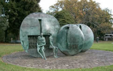
The Bronze Fountain “Karangahape Rocks” is installed in Symonds Street Park.
1970-9
Large volumes of railings and masonry elements are removed by Council .
1982
Work commences on path refurbishment and some monument repairs. This is made possible through Government Sponsored PEP schemes.
march 1993
Work on “The Symonds Street Conservation Plan” commences.
1994
A new photographic survey of all headstones is undertaken by Auckland City Council.
1994
Council grants consent for sale of easement on part of the St Martins Lane frontage.
1995
All remaining burial information is collated into a single database by Auckland Council Libraries.
1996
Guidelines prepared for Memorial Repairs and Gravesite Restoration.
2000
The Tibor Donner building in the Symonds Street Park is demolished.
2013
Friends of the Symonds Street Cemetery is formed.